


Special offers from our partners!

Find Replacement BBQ Parts for 20,308 Models. Repair your BBQ today.

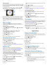
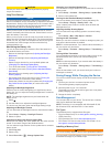
Course Pointer
The course pointer is most useful if you are navigating on water
or where there are no major obstacles in your path. It also helps
you avoid hazards to either side of the course, such as shoals
or submerged rocks.
To enable the course pointer, from the compass, select >
Setup Heading > Go To Line/Pointer > Course (CDI).
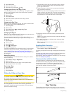
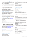
The course pointer
À
indicates your relationship to the course
line leading to the destination. The course deviation indicator
(CDI)
Á
provides the indication of drift (right or left) from the
course. The scale
Â
refers to the distance between dots
Ã
on
the course deviation indicator, which tell you how far off course
you are.
Where To? Menu
You can use the Where To? menu to find a destination to
navigate to. Not all Where To? categories are available in all
areas and maps.
Finding a Waypoint by Name
1
Select > Where To? > Waypoints > > Spell Search.
2
Enter the name.
3
Select .
Finding a Waypoint Near Another Waypoint
1
Select > Waypoint Manager.
2
Select a waypoint.
3
Select > Find Near Here.
4
Select a category.
The list displays waypoints near the original waypoint.
Navigating with Sight 'N Go
You can point the device at an object in the distance, lock in the
direction, and navigate to the object.
1
Select > Sight 'N Go.
2
Point the device at an object.
3
Select Lock Direction > Set Course.
4
Navigate using the compass (Navigating with the Bearing
Pointer) or map (Map).
Elevation Plot
By default, the elevation plot displays the elevation for an
elapsed time. You can customize the plot (Changing the Plot
Type) and the data fields (Customizing the Data Fields).
To open the elevation plot, select > Elevation Plot.
Calibrating the Barometric Altimeter
You can manually calibrate the barometric altimeter if you know
the correct elevation or the correct barometric pressure.
1
Go to a location where the elevation or barometric pressure
is known.
2
Select > Elevation Plot > > Calibrate Altimeter.
3
Follow the on-screen instructions.
Navigating to a Point on the Plot
1
Select > Elevation Plot.
2
Select an individual point on the plot.
Details about the point appear in the upper-left corner of the
plot.
3
Select > View Map.
4
Select the information bar along the top of the screen.
5
Select Go.
6
Navigate using the compass (Navigating with the Bearing
Pointer) or map (Map).
Changing the Plot Type
You can change the elevation plot to display pressure and
elevation over time or distance.
1
Select > Elevation Plot > > Change Plot Type.
2
Select an option.
Resetting the Elevation Plot
Select > Elevation Plot > > Reset > Clear Current
Track > Yes.
Trip Computer
The trip computer displays your current speed, average speed,
maximum speed, trip odometer, and other helpful statistics. You
can customize the trip computer layout, dashboard, and data
fields (Customizing the Data Fields).
To open the trip computer, select > Trip Computer.
Resetting the Trip Computer
For accurate trip information, reset the trip information before
beginning a trip.
Select > Trip Computer > > Reset > Reset Trip Data
> Yes.
Applications
Setting a Proximity Alarm
Proximity alarms alert you when you or your dogs are within a
specified range of a particular location. A tone sounds when you
enter the designated radius.
1
Select > Proximity Alarms.
2
Select Create Alarm.
3
Select a category.
4
Select a location.
5
Select Use.
6
Enter a radius.
When you enter an area with a proximity alarm, the device
sounds a tone.
Calculating the Size of an Area
1
Select > Area Calculation > Start.
2
Walk around the perimeter of the area you want to calculate.
3
When finished, select Calculate.
Viewing the Calendar and Almanacs
You can view device activity, such as when a waypoint was
saved, and almanac information for the sun and moon, and
hunting and fishing.
1
Select .
2
Select an option:
• To view device activity for specific days, select Calendar.
• To view the sunrise, sunset, moonrise, and moonset
times, select Sun and Moon.
• To view the predicted best times for hunting and fishing,
select Hunt and Fish.
Applications 11