


Special offers from our partners!

Find Replacement BBQ Parts for 20,308 Models. Repair your BBQ today.
Jeppesen database
Coverage: Americas or International
Airports: Identifier, city/state, country, facility name,
lat/long, elevation, fuel service, control,
approach information
VORs: Identifier, city/state, country, facility name,
lat/long, frequency, co-located DME/TACAN,
magnetic variation, weather broadcast
NDBs: Identifier, city/state, country, facility name,
lat/long, frequency, weather broadcast
Intersections: Identifier, country, lat/long, nearest VOR
Frequencies: Approach, arrival, control area, departure,
Class B, Class C, TMA, TRSA—with sector,
altitude and text usage info; also, ASOS, ATIS,
AWOS, center, clearance delivery, ground,
pre-taxi, tower, unicom, localizer and ILS
Runways: Designation, length, width, surface, lighting,
pilot-controlled lighting freq.
FSS: Identifier, reference VOR, freq. usage
ARTCC: Identifier, freq. usage
MSA: Minimum safe altitude along and in
proximity to active flight plan
Approaches: Non-precision and precision approaches
throughout the database coverage
SIDs/STARs: Contains all pilot-nav SIDs and STARs
Airspaces: Class B and C with sectors, International CTA
and TMA with sectors; all special-use airspace,
including MOA’s, prohibited and restricted
areas—with controlling agency and airport
Safety features
Emergency search: 9 nearest airports, VORs, NDBs,
intersections, or user waypoints;
5 nearest FSS and ARTCC frequencies
Alarms: Arrival and CDI; timers; airspace alarms
at 10 minutes, 2 nm and inside airspace
User customization
Waypoints: 1000 user-defined
Flight plans: 20 reversible; up to 31 waypoints each
Certifications
GPS: TSO C129a, Class A1
(en route, terminal and approach)
VOR: TSO C40c
LOC: TSO C36e
GS: TSO C34e
VHF COM: TSO C37d, Class 4 and 6 (transmit) and
TSO C38d, Class C and E (receive)
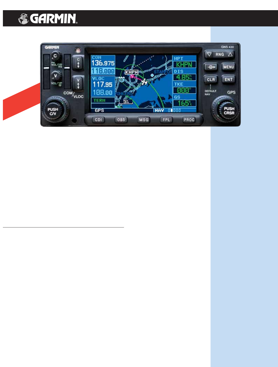
GNS 430 specifications
The Garmin GNS 430 has
become known as the “one
box.” Because while many avion-
ics components offer some of the capabilities of the GNS
430, it’s the integration of so many different capabilities
into a single unit that makes the GNS 430 unique. It’s a
comm/nav/GPS with brilliant color map graphics all rolled
into one.
The GNS 430 continues in the Garmin tradition of easy
operating software. Logic prevails to make sense of massive
amounts of pilot-specific data. To access this information you
merely need to master two concentric knobs and a series of
function buttons. All backlit. All right where you’d want them.
The most striking thing about the GNS 430 is how easy
it is to read and interpret. At the heart of the on-screen
data is a user-configurable color map. Of course, you can
monitor your flight plan using navigation chart graphics.
But you can also enjoy the greatest in situational awareness
with a detailed cartography database that shows airports,
cities, political boundaries, highways, railroads, rivers, lakes
and coastlines.
At the heart of the unit is a WAAS upgradeable,
12-channel GPS receiver with a 10-watt comm. The GNS 430 "A"
offers 16-watt comm transmitting power for enhanced
performance for high altitude aircraft. All 400-series units
offer Fault Detection and Exclusion (FDE) software for
Oceanic Approval.
No matter what your performance requirements,
GNS 430/430A
16 watt comm
available on the
GNS 430 "A"